One on One with Google Maps Engine
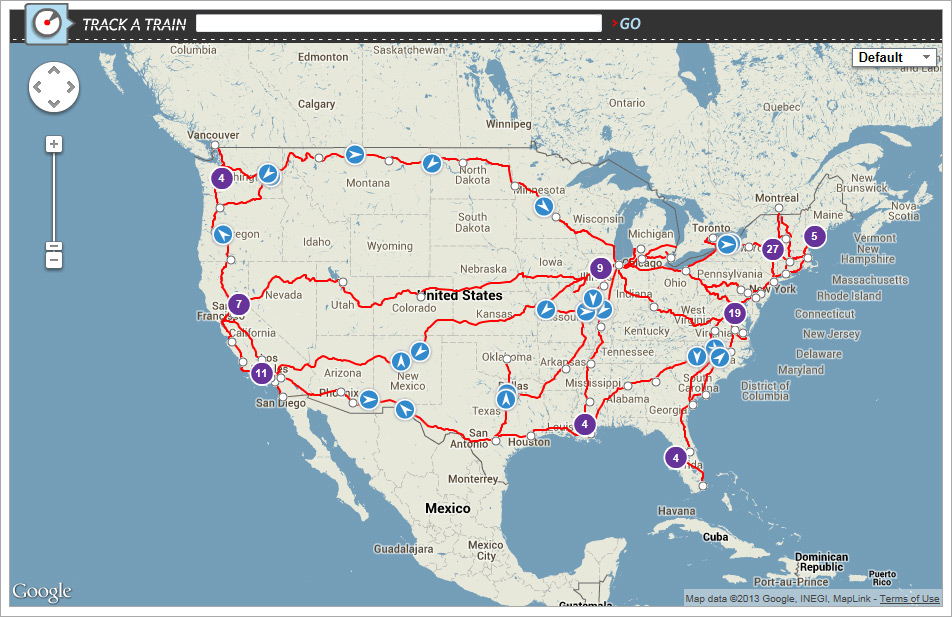
 Today we’re launching a new interactive tool that we created with Google to help you track any of our more than 300 daily trains and more accurately predict arrival times. The map covers coast to coast movements, 365 days a year and can be accessed 24 hours a day with just the click of a mouse.
To learn more about the technology behind the map, we talked to Dylan Lorimer, product manager for Google Maps for Business.
Amtrak travels to more than 500 destinations and dispatches more than 300 trains every day. How does Google Maps Engine ensure complex information on maps isn’t overwhelming for users?
Google Maps Engine is a cloud-based mapping solution that lets organizations create custom Google maps with their own data. A good example of this is Amtrak’s newly launched train locator tool. While Maps Engine provides Amtrak with the infrastructure needed to host and support its complex train status information, it also allows amtrak.com users to see this information on a Google Map. By displaying train locations on a map interface that travelers are already familiar with, Amtrak customers can quickly and efficiently get the information they need.
 We have more than 31 million customers, so keeping a lot of people informed about the status of our trains is essential. How accessible is this technology?
Google Maps Engine helps Amtrak ensure that its millions of customers can get the information they need, no matter how many people visit their website. This is made possible by Google’s fast, reliable cloud infrastructure – the foundation of Google Maps Engine. By using Maps Engine for its train locator map, Amtrak can utilize the same cloud technology that supports Google properties such as Google Search, Gmail and YouTube, allowing its train location information to be accessible to more than 31 million customers anytime, anywhere on any device.
At Amtrak, we pride ourselves on connecting communities all over the country, particularly those with limited options for connections to the national intercity transportation system. How important is it for Americans to understand their country and transportation options through geospatial data?
As a product manager for Google Maps Engine, we’re focused on making map creation and publishing more accessible to a broad set of enterprise users. We refer to this as “democratizing GIS.” One of our key initiatives is to bring easy-to-use, familiar mapping tools to our customers and their users. People should have access to useful, accurate and comprehensive map information to help them make informed decisions no matter where they are. We want to provide businesses, like Amtrak, with technology solutions to help make this possible.
As you know, our trains go to a lot of places. If you could go to any of our 500 destinations, where would you go?
Remember that train robbery scene from Breaking Bad (season 5, episode 5), where they steal the supply of methylamine? Maybe there? Just kidding. For sure, I’d take the Empire Builder through Glacier National Park! I can’t wait to do that one day.
To see the new Google-enabled technology in action go here.
Read More All Aboard!: Google Helps Amtrak Help You Track Trains
Share This Post